Polar Tours Logo 1200px full color svg

All Trips

Trip Type

Antarctica

Arctic

Info

Home

All Trips

Trip Type

Ship Size

All Ships & How to choose the best

Large Ships

Micro-Cruises

Mid-Sized Ships

Small Ships

Ways to travel

Classic Cruises

Discounted Cruises

Luxury Cruises

Polar Expeditions for Solo Travelers

Premium Cruises

Antarctica

Antarctica

All Dates+Prices

Antarctic Season 2025/2026

Antarctic Season 2026/2027

Antarctica Travel Information

Download Our Free Antarctica Guidebook

Weather in Antarctica

Wildlife of Antarctica

Top Destinations

Cruises beyond the Arctic Circle

Falklands Islands

King George Island

South Georgia

South Orkney Islands

South Shetland Islands

Travel Styles

Air Cruises: Fly to Antarctica!

Antarctica Last-Minute

Antarctica Luxury Cruises

Cheapest Antarctica Cruises

More Comfort: Antarctica Large Ship Cruises

Small Ship Expedition Cruises to Antarctica

Trips for Solo Travelers

Arctic

Arctic

All Dates+Prices

Arctic Travel Information

Download Our Free Arctic Guidebook

Wildlife of the Arctic

Top Destinations

Canadian Arctic

Greenland

Iceland

North Pole

Northern Lights Cruises

Northwest Passage

Svalbard

Travel Styles

Arctic First Class Cruises

Arctic Luxury Cruises

Arctic Small Ship Expedition Cruises

Artic Last Minute Cruises

Discounted Arctic Cruises

Polar Bear Tours

Small Ship Cruises in Svalbard

Trips For Solo Travelers

Info

Advantages When Booking With Us

All deals in one place

Best Price Guarantee

Free Video Consultation

No Hidden Fees

Unbiased Recommendations

Why book with us?

Your money is protected

Info

Activities & Add-Ons

Blog

FAQ

Free Polar Guidebook

Our Team

Sustainable Tourism

Travel Insurance for EU + CH Residents

What our travelers say

YouTube: Polar Expert Talks

Contact us

Weekdays from 11:00 to 22:00 CET

$
​
​
$
​
​

Sign up for our Polartours newsletter

Get travel inspiration from Antarctica and the Arctic and receive exclusive discounts.

​
Polar Tours Logo 1200px full color svg

Luxury Cruises

Island Sky

SH Diana

Scenic Eclipse I

Silver Cloud

Silver Explorer

Silver Wind

Ultramarine

Premium Cruises

Douglas Mawson

Freya

Greg Mortimer

Hebridean Sky

Kinfish

Magellan Discoverer

Magellan Explorer

Classic Cruises

50 Years of Victory

G-Expedition

Hans Hansson

Hondius

Janssonius

Kapitan Khlebnikov

MS Balto

Further Links

Best Price Guarantee

Ernest Shackleton

Join our team!

Last Minute Deals

Mandatory Insurance

Packing List

Trips departing from Punta Arenas

Further Information

FAQ

Terms & Conditions

Jobs

ventura TRAVEL

Contact Us

🇺🇸 +1 347-493-2978

🇬🇧 +44 20 4571 8661

🇩🇪 +49 30 3119 3691

🇫🇷 +33 1 76 38 06 39

[email protected]

Contact Form

Weekdays from 11:00 to 22:00 CET

Horseshoe Island

This remarkably preserved scientific station is a 1950s time capsule

Information about Horseshoe Island

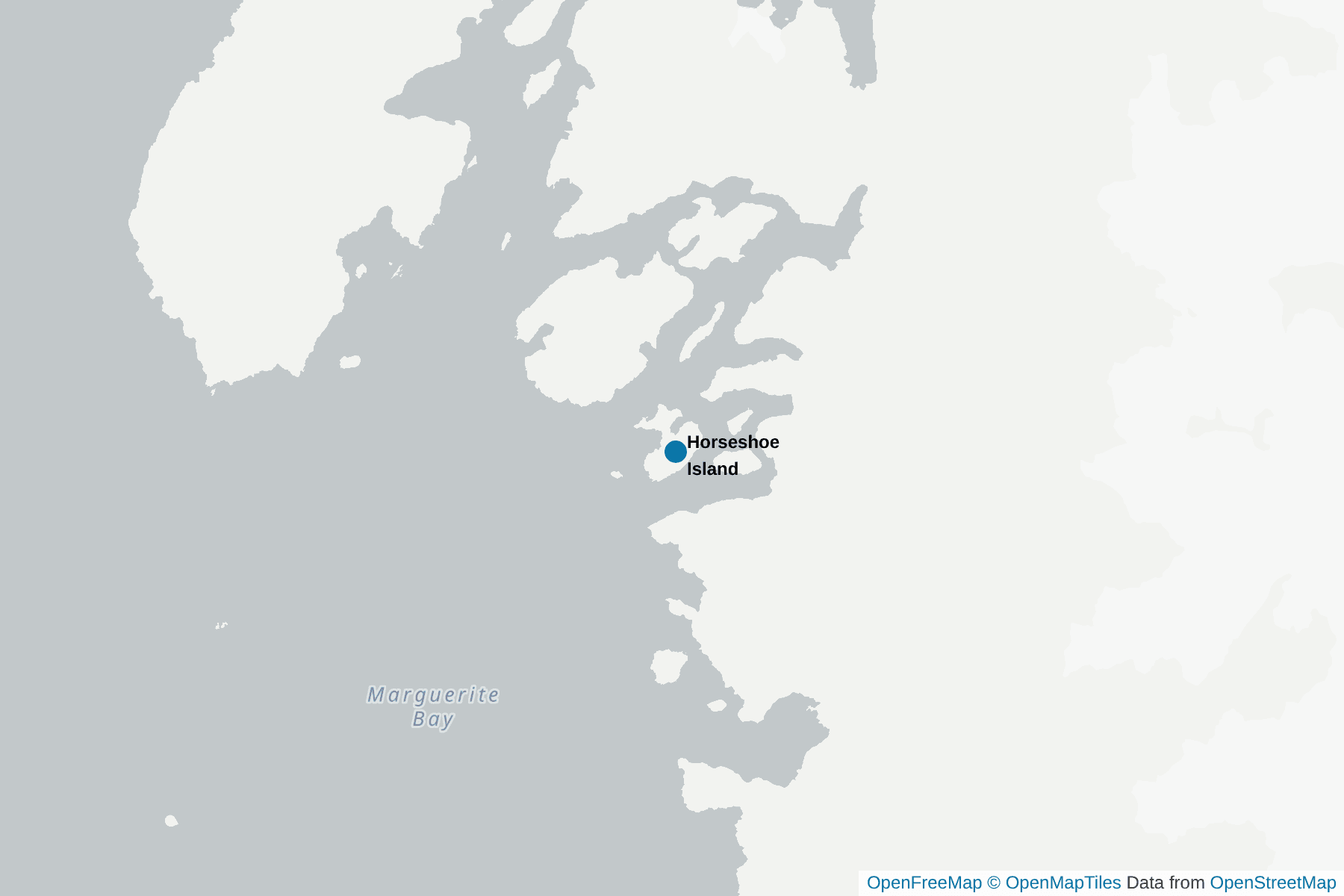
Horseshoe Island is well named. The 3000ft high peaks here are arranged in a crescent shape and were first mapped by air by intrepid British explorers in the 1930s. The island sits in Square Bay, off the coast of Graham Land in Marguerite Bay, well to the south of the Antarctic Circle.

The landing tends to be the northwestern tip of Horshoe Island in Sally Cove. From here, it’s a short walk north to the amazingly preserved hut known as “Base Y” or Horseshoe Station.

This was established in 1955 as a scientific base and was closed permanently in 1960 when personnel were transferred to Stonington Island's Station E nearby. Although unused for over 60 years, Base Y is in a remarkable state of preservation and represents a model example of a fully-equipped exploration and scientific base of the time.

Inside the hut, you will be able to carefully explore by torchlight as you see artifacts from a bygone age. These include the original base generator, tools, light fixtures, tins and packets of original rations, and more items from the daily lives of the scientists who made Horseshoe Island their temporary homes.

Although this time-capsule building is the star of the show, it’s not unusual to encounter seals and skuas on or near to the landing site here.

Interesting facts about Horseshoe Island

British Base ‘Y’ is designated as Historic Site and Monument No. 63. It sits on a small peninsula at the northwestern end of the island overlooking Sally Cove. It is noteworthy as a relatively unaltered and well equipped British scientific base of the late 1950s, providing a time capsule of life and science of the time. It was occupied continuously from March 1955 to August 1960, and re-opened for a 4 month period in 1969. In addition to the base building, there is also a balloon shed, pup pens, an emergency store, two pram dinghies and a winch. ‘Blaiklock’, the refuge hut located several miles away, is considered an integral part of the base.

Pictures of Horseshoe Island

+2

Highlights Close to Horseshoe Island

detaille island
Detaille Island

Detaille Island is a small island in the Lallemand Fjord, part of the Arrowsmith Peninsula in Graham Land. It’s not much more than a rocky outcrop with gravel beaches, but it contains one of the best-preserved historic monuments in the Antarctic.

Detaille was home to “Base W” of the British Antarctic Survey. It was constructed in 1956 and was in use until 1959 when it was closed. Due to bad weather, the supply ship that was sent to take the men and equipment off the island couldn’t get any closer than 30 miles away. This meant that the men had to leave very quickly and with only the personal belongings that they could carry so the ship could depart as quickly as possible.

Because of these circumstances, Base W is almost completely intact. As you look around the hut you will be greeted with the eerie sight of tables still set out with condiments, shelves stacked with tin and jars, and everyday equipment like washing machines, tools, and even and bottles of gin and whisky (empty!). Longjohns and coats are half discarded, with magazines open on the tables, as they were left when the base was abandoned!

Preserved by the United Kingdom Antarctic Heritage Trust, this is a remarkable insight into the early post-war scientific explorations of this amazing continent, and it makes Detaille Island and Base W a “must-visit” on any Antarctic itinerary.

It is also a good location for a Zodiac place with the 'deep south' scenery (it is just south of the Antarctic Circle), the ice, and to look out for seals and Adelie Penguins.

half moon island
Half Moon Island

Half Moon Island is rugged and rocky and lies just off the Bergas Peninsula in the South Shetland Islands and it is a very popular spot as the either the first or last landing on an Antarctic Peninsula cruise. One side of Half Moon Island has steep, scree-covered slopes and cliffs down to the water, an ideal home to many Antarctic sea birds. The other parts of the island are characterized by pebble and boulder beaches leading to shallower slopes.

Visitor numbers are strictly controlled to ensure that the resident terns, gulls, and penguins aren’t disturbed, especially during their breeding seasons.

Your landing site is a cobbled beach where the remains of a whaling dory (a type of shallow, planked boat) can be seen.

As well as penguin colonies close to the shore, your Antarctic exploration guides will show you the Half Moon Island chinstrap penguin nesting sites near a navigation tower at the top of the hill, as well as the amazing Wilson’s Storm Petrel burrows that have been dug into the scree slopes here. Half Moon has also had a lone Macaroni penguin for a number of years, and others occasionally turn up here.

Your guides will also show you the areas where you can roam freely, always keeping an eye out for Fur Seals whose colors camouflage themselves against the rocks.

Half Moon Island is also home to the Argentinian Summer Antarctic Research Station. You may well spot scientists undertaking important surveys and research work during your visit.

The is also the stunning backdrop of the snow covered and rugged Livingstone Island with the tumbling glaciers.

peterman island
Petermann Island

Petermann Island marks the extremes for two Antarctic species - not bad for a small rock less than a mile long!

This rocky outcrop that rises 500ft above the sea has a permanent covering of ice. The island is just south of Booth Island in the Lemaire Channel. Petermann Island is volcanic in origin, and it has a permanent icecap covering more than half of its surface. It’s home to the northernmost colony of Adelie penguins, but also the southernmost colony of Gentoo penguins. The latter are taking over (and pushing further souht) and soon there may be no breeding Adelie Penguins on Petermann Island.

First mapped by a French expedition in 1909, Petermann Island is also home to breeding colonies of skuas and Wilson’s storm petrels. There’s also a good chance to observe Weddell, crabeater, and fur seals.

Visitors can hike up to the highest point of the island, where a cross and cairn remembers three members of the British Antarctic Survey who died in 1982 attempting to cross the sea ice from Petermann Island to Vernadsky station. There is also a refuge hut built by an Argentinian expedition in 1955 - its red metal walls make a fantastic contrast against the snow and ice.

The area can be superb for Zodiac cruises, especially around the larger icebergs grounded on the far side of the island, and Humpback Whales often appear in the main channel.

Image without description
Pleneau Island

Pleneau Island is one of the less-visited Antarctic visitor sites but is well worth it. First mapped in 1903 by the French Charcot expedition, it’s a beautiful location that overlooks what’s known as an “iceberg graveyard”, with a Zodiac cruise often favoured over a landing (see fascinating facts). Whether viewed from the island itself or from a Zodiac, there are always stunning ‘bergs to photograph here.

The island itself is less than a mile long and lies just off Hovgaard Island in the Wilhelm Archipelago. Pleneau is home to terns, and your expert Antarctic guides will make sure that you avoid disturbing them in the breeding season.

The permanent ice cap at the top of the island looks stunning, but it’s riddled with crevasses and not safe to walk on.

The northern end of the island hosts a breeding colony of Antarctic Shags, and you will almost certainly see penguins and seals among the stunning icebergs.

Image without description
South of the Polar Circle

The Polar Circles are two imaginary lines in the northern and southern hemispheres that denote where the Arctic and Antarctic begin.

For us, everything south of our polar circle is Antarctica. There are actually very few bases or scientific stations inside the southern polar circle as the ice conditions make getting personnel and equipment in and out difficult by ship and treacherous or impossible by air.

However, Argentina and the UK do manage to maintain permanent stations in Marguerite Bay, and Chile has a summer station at the bay entrance. This bay is below the polar circle, and your ship will do its best to cross the “line” here by sailing beyond the Biscoe Islands towards the bay if sea and ice conditions permit.

It’s a moment to celebrate, and perhaps to reflect on the lives lost in the human endeavor to explore every part of our world and to understand it for the benefit of future generations.

stonington island
Stonington Island

For such a tiny, rock island (it’s less than half a mile by a quarter of a mile), Stonington holds a lot of the human history of Antarctica. It’s found in Marguerite Bay off the west of Graham Land, and it is one of the most southerly historic sites on the peninsula.

It was home to not one, but two winter expeditions. In 1939, the US Antarctic Service chose it as the location to build what became known as East Base. The buildings and artifacts here are now protected as a monument. Visitors can enter the main hut to experience something of what it would have been like to spend the dark and frozen winters on Stonington.

Later in the 1940s, the British chose the same small island for the location of their “Base E”. Again, visitors can enter the main hut and also the generator shed. Like the American base, there are other ancillary buildings that can’t be entered due to their status as protected monuments. There are permanent shutters on the windows of Base E, so your guide should provide you with torches if you venture inside.

In a solemn reminder of the harshness of the continent, there is also a gravesite where two expedition members are buried in coffins covered by simple stone cairns.

Stonington Island supports a colony of over 130 pairs of Antarctic Shags, as well as nesting sites for skuas and terns. As well as the landing there is a good Zodiac cruise around the island with the head of the nearby glaciers coming down from the polar plateau and to look out for seals and Adelie Penguins on the ice floes.

Later in the season fur seals and Humpback Whales can turn up at this southerly destination.

Image without description
Torgersen Island

Torgersen Island is a very small, circular island only 450yds across. It’s part of the Palmer Archipelago and is at the entrance to Arthur Harbour on the southwest coast of Anvers Island.

It’s a popular site for breeding seabirds and Adelie penguins, but this small rock has a much larger, and more depressing, importance.

Although the current colony size of 3,000 breeding pairs seems large, since 1974 the Adelie population has reduced by over 60% due to the impact of climate change on the sea ice and snowfall patterns. An Adelie colony that was based on the neighboring Litchfield Island has disappeared completely in this time. Archeological surveys showed that penguins had been nesting there for over 600 years continuously, with up to 15,000 pairs in residence at a time. By 2007 they had all gone.

The island is very close to the American Palmer Station and it is divided into a Visitor Zone and a Restricted Zone. The Visitor Zone is for general access, whilst the Restricted Zone serves as a control site for scientific research related to human impacts. The Restricted Zone should not be entered, except in an emergency to access the emergency cache located on slopes opposite the landing site. Use the cache only in a genuine emergency and notify Palmer Station if anything is used.

Your expert Antarctic guides will show you the walking routes to take that will minimize any impact to the Adelie colony on Torgersen Island, as well as outlining the concerns that Antarctic scientists have about the continuing impact of climate change on the region’s wildlife.

This is a timely reminder of the necessity for change in the way humans live and use fossil fuels if we are to preserve the unique species and landscapes of the Antarctic. At Polartours we are playing our part in this story by carbon offsetting every polar cruise package we sell.

Wordie house
Wordie House, Winter Island

Nestled onto the only flat part of Winter Island, Wordie House is a hut built in 1947. It was named by a British Antarctic expedition of the time after James Wordie, who was the chief scientist on Shackleton’s famous 1914 Antarctic exploration. Winter Island is less than 1,000 yards long and is one of the Argentine Islands off the coast of Graham Land.

Before it closed in 1954, the hut was used to take meteorological readings using instruments stored inside special screens, one of which still stands today. These readings were among the most important and longest set of weather data ever recorded about the Antarctic and helped scientists gain a greater understanding of the meteorology of the continent.

Wordie House was made a “Historic Site and Monument” in 1995 and has been looked after by the UK Antarctic Heritage Trust since 2009. There are almost 500 original artifacts still on the site, including original cans of coffee, records, pots and pans, plates, and many more £everyday” items. This makes Wordie House a true time capsule from the golden age of Antarctic exploration and scientific research. The hut is now fully weathertight, and work continues on preserving this unique station.

Close to Wordie House there used to be the British Faraday base, the place where researcher's discovered the expanding Ozone hole. When the base was going to close, rather than dismantling this important and historic base (and one of the best bars in Antarctica!), it was given to the Ukraine for one pound!

Visits to Winter Island and Wordie House are managed by the nearby Ukrainian station Vernadsky, and you may well be briefed by the Base Commander or other official before you board your boats for the landing. The visit to Wordie House is often in conjunction with a visit to the base, and the chance to have a vodka and the impressive wooden bar.

The short Zodiac cruise between the two locations passes through some interesting gullies and the chance to check out seals and penguins on small ice floes.

Uniquely for such a historic site, visitors are allowed to roam freely under the supervision of their expert Antarctic guides. They will answer all your questions about the history of the hut, as well as the artifacts that you can find here.

Visitors to Winter Island can also expect to see seabirds such as skuas and kelp gulls, as well as seals and penguins. Humpback Whales are often seen in the more open waters close to the anchorage.

yalour islands
Yalour Islands

The Yalour Islands (also sometimes called Jalour Islands) are a 1.5-mile long group of small islands and protruding rocks off Cape Tuxen in Graham Land. The islands were discovered and named in 1903 by the French Antarctic expedition led by Charcot.

Most of the Yalour Islands are steep-sided or unsuitable for landing due to sea conditions, but the largest island has some cobbled beaches where you can put ashore.

Visitors come here to make the short climb up from the beach to the Adelie penguin breeding colonies. There are thought to be around 8,000 breeding pairs of Adelies in the Yalour Islands, and they have nested on every bit of rock they can find that’s not snow-covered. It makes for an amazing sight as you come in to land on the beach!

Photographic opportunities here are excellent. The high mountains of the Antarctic Peninsula form a stunning backdrop to shots of the Adelie nest sites. Your expert guides will lead you around, showing you the best sites, and answering all your questions about the penguins and their lives.

As Adelie Penguins have decreased in numbers just to the north at locations like the Petermann Islands, the Yalour Islands have become a popular location to see this species. Even if it is a challenge to get ashore with the swell, or, the snow banks earlier in the season, the colonies are easily observed from a Zodiac. The area can be a good spot for seals, and for Humpback Whales offshore.

Animals in Horseshoe Island

Please be aware that wildlife sightings are never guaranteed and depend on seasons, weather, and other factors.
Polartours

Brown or Antarctic Skua

Polartours

Kelp Gull

Polartours

Leopard Seal

Polartours

Weddell Seal

Polartours

Crabeater Seal

Our trips to Horseshoe Island

Bruna Garcia

Your contact

Bruna

Call now

+1 347-493-2978

Weekdays from 11:00 to 22:00 CET

​
​
​
​
​
​
Bruna Garcia