%3Aformat(webp)%2Fheader_media%2F53d22f3b-a72e-4c48-9814-43a44f011a40-ronge_island_-16100202330-.jpeg&w=1920&q=75)
Georges Point, Rongé Island
Snowy peaks give the perfect backdrop to a beach full of penguins and seals.
Information about Georges Point, Rongé Island
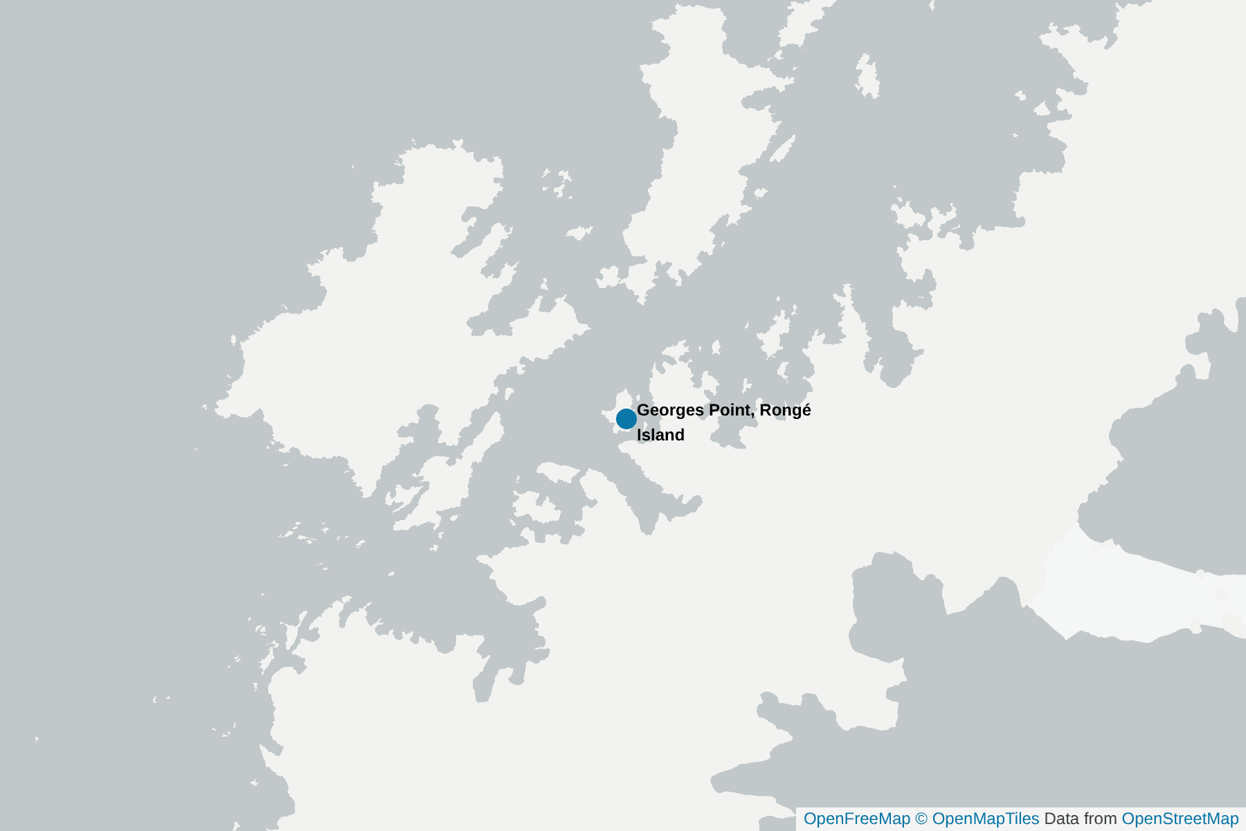
Rongé Island is high and rocky. Some 5 miles long, it’s the largest of the islands that form the west side of the Errera Channel, off Graham Land.
Georges Point was first mapped in 1897 by the Belgian Antarctic Expedition and named after one of its members.
You land on a rocky beach that looks across to Cuverville Island. There is a penguin colony at one end that your expert Antarctic guides will guide you around, with lots of Gentoo Penguins and Chinstrap Penguins higher up. They will also take you on a carefully marked trail up to the higher ground behind the beach giving you a great view down over the concentrations of penguins along the shore, and the view over the bay towards Cuverville Island and the peninsula.
Later in the season there are also often Antarctic Fur Seals to be found at Georges Point on Rongé Island as well as plenty of sea birds. The rocky cliffs and height of the island make for some magnificent backdrops and great opportunities to capture the essence of the Antarctic in your photographs.
Interesting facts about Georges Point, Rongé Island
Scientific equipment is present in this site.
Pictures of Georges Point, Rongé Island
%3Aformat(webp)%2F0868589f-65f3-4bf4-97f9-368e710d8a2f-antarctica--visitor-site-georges-point-2.jpg&w=1920&q=75)
%3Aformat(webp)%2F061e86a9-9d0a-4814-99f9-1f04b72f3d97-antarctica--visitor-site-georges-point-1.jpg&w=1920&q=75)
+1
%3Aformat(webp)%2F126de4e9-583c-4ca6-ae3d-e8c36f82be71-antarctica--visitor-site-georges-point-3.jpg&w=1920&q=75)
Where is Georges Point, Rongé Island
Highlights Close to Georges Point, Rongé Island
%3Aformat(webp)%2Ftrip%2Fb31087c7-d212-4da8-897e-4969ff497f6e-spirit-of-antarctica-ice.jpg&w=1920&q=75)
%3Aformat(webp)%2Fb6565a47-ded2-4efa-b85f-e043bc4b1670-1280px-00_2118_antarctica_-_cuverville_island.jpg&w=1920&q=75)
%3Aformat(webp)%2Fheader_media%2F2e376abf-b598-41eb-a8bf-dfe1df76c7ea-6932910704_58cf5a7c1a_b.jpeg&w=1920&q=75)
%3Aformat(webp)%2Feb8fc057-88df-4b30-aaf6-9a2caf2988c6-antarctica--visitor-site-danco-2.jpg&w=1920&q=75)
%3Aformat(webp)%2Fheader_media%2Ff96cfed8-6af9-4332-a50f-02fe1dc7abb8-gentoo_penguins_at_trinity_island-_antarctica.jpeg&w=1920&q=75)
%3Aformat(webp)%2Fcc3bb842-0131-48d2-ab49-2d3d87491366-goudier_island-2016-port_lockroy_02.jpg&w=1920&q=75)
%3Aformat(webp)%2Fheader_media%2F453b69e9-4153-47dd-ae1f-a71a9dc8837f-pygoscelis_papua_-jougla_point-_wiencke_island-_palmer_archipelago_-adult_on_nest-8.jpeg&w=1920&q=75)
%3Aformat(webp)%2Fheader_media%2F1db5283a-72c9-47d8-a854-62f96579afaf-c-1-min-08-sec-neko-harbour-and-ms-expedition-nw-peninsula-24-2-19-k-morgan.jpg&w=1920&q=75)
%3Aformat(webp)%2Fheader_media%2Fa3f9a3b3-ce87-4d89-9b89-ed180dde1c72-orne_harbor-_antarctica_-24940429415-.jpeg&w=1920&q=75)
%3Aformat(webp)%2Fheader_media%2F3dc4c532-7f79-4adc-87eb-3151ebf8f686-f1beb97ccefc46212a04e0d4bb428cf0ac83f6c8-1-.jpeg&w=1920&q=75)
%3Aformat(webp)%2Fheader_media%2Fe064dbfc-c765-4a6d-8916-455a2df34746-49415083867_394b2e5011_b.jpeg&w=1920&q=75)
%3Aformat(webp)%2F6d29473e-eae9-43a6-b5ff-c098b80fdd40-antarctica--visitor-site-portal-point-1.jpg&w=1920&q=75)
%3Aformat(webp)%2Fb5faac46-3550-4d92-9112-a95474cd7ca8-drawimage.jpeg&w=1920&q=75)
Animals in Georges Point, Rongé Island
Please be aware that wildlife sightings are never guaranteed and depend on seasons, weather, and other factors.
%3Aformat(webp)%2Fheader_media%2Fffed0dce-ffe2-4418-887b-34ecada4447b-weddell-seal-oceanwide-.jpeg&w=1920&q=75)
%3Aformat(webp)%2Fheader_media%2Ff86d7d6a-8604-4bf0-8fa8-2e4eb22bf385-subantarctic-skua-or-brown-skua-omar-runolfsson-.jpg&w=1920&q=75)
%3Aformat(webp)%2Fheader_media%2F7fb10df7-905a-444f-815d-46b527076e2d-00_0074_gentoo_penguin_in_antarctica.jpeg&w=1920&q=75)
%3Aformat(webp)%2Fheader_media%2F907fa4ce-5196-4200-b84a-7225a7db4dff-snowy_sheathbill.jpeg&w=1920&q=75)
%3Aformat(webp)%2Fheader_media%2F8fe16a88-61d9-4125-ba77-d7256ca8f553-antarctic-fur-seal.jpg&w=1920&q=75)
%3Aformat(webp)%2Fheader_media%2Fdb0dc770-c12c-4e5f-b896-8d4f90778fe5-southern-giant-petrel-graham-curran-.jpg&w=1920&q=75)
%3Aformat(webp)%2Fheader_media%2F1cc67a57-e08d-43a9-8db0-b3c61d5338bd-leopard-seal.jpg&w=1920&q=75)
%3Aformat(webp)%2Fheader_media%2F9eb76886-dc7e-4092-b590-9dc2d71bbd6b-southshetland-2016-livingston_island_-hannah_point-kelp_gull_-larus_dominicanus-.jpeg&w=1920&q=75)
%3Aformat(webp)%2Fheader_media%2F66bc8ae9-172a-42a3-8819-69f0a5374be5-chick_and_adult_antarctic_tern.jpg&w=1920&q=75)
%3Aformat(webp)%2Fheader_media%2F739551ed-c4fb-4423-a43c-bde273b32ea6-chinstrap-penguin-oceanwide-.jpeg&w=1920&q=75)
%3Aformat(webp)%2Fheader_media%2Ffc3ec3da-ee63-4642-8dbb-36862b15adb2-wilson-s-storm-petrel-john-harrison-.jpg&w=1920&q=75)