King Eider

King Eider

Stunning regal plumage sets the males of this species apart


What you need to know about the King Eider

Our Expert Says… "These stunning birds are warier than the common eider ducks who seem to relish the attention of you and your fellow explorers! Your guide should slow the Zodiac down if they spot King eider so that everyone gets the chance to see them before they take flight. The remarkable plumage makes them absolutely worth the extra effort to get a good sighting and a photo."

The king eider is a breeding sea duck of the high Arctic. Large in size, king eiders grow up to 70cm (28”) long and have wingspans of up to 1m (40”). Males can weigh over 1.6kg (3.5lb).

The male king eider is unmistakable thanks to his rather regal-looking plumage! The body is almost all black, but the breast is buff-colored and the head is a pale blue-gray color, with a green flash under the eye. The bill is pinkish-red with a large and distinctive yellow knob at the base. It’s this “crown-like” feature, together with the striking coloring, that gives this eider its royal name!

The female king eider is brown overall, with black wing markings and fine black lines to the head and neck.

King eider can be found throughout the arctic region, including the coasts of Alaska, Russia, Greenland, and Svalbard. Eiders move slightly south for the winter, spending the season out at sea in flocks of up to 100,000 in places like the Bering Sea and the waters off Northern Norway among others.

In summer, they move further north where they build nests near water. The females scrape out a shallow dip in the ground which they line with moss and grasses and their own down in common with all eider ducks. The males don’t get involved with rearing the chicks, but the females tend to collectively rear their young in larger creches.

When it's at sea, the king eider feeds almost exclusively on food like mollusks, crabs, sea urchins, and starfish that live in the sediments on the sea bottom, so it prefers shallower waters. During the breeding season, they tend not to dive but dabble at the surface for smaller invertebrates.

Although mature king eiders have relatively few predators, the chicks and young have a harder time of it, regularly being preyed on by species like glaucous gulls, Arctic foxes, and parasitic jaegers.

Pictures of King Eider

King Eider

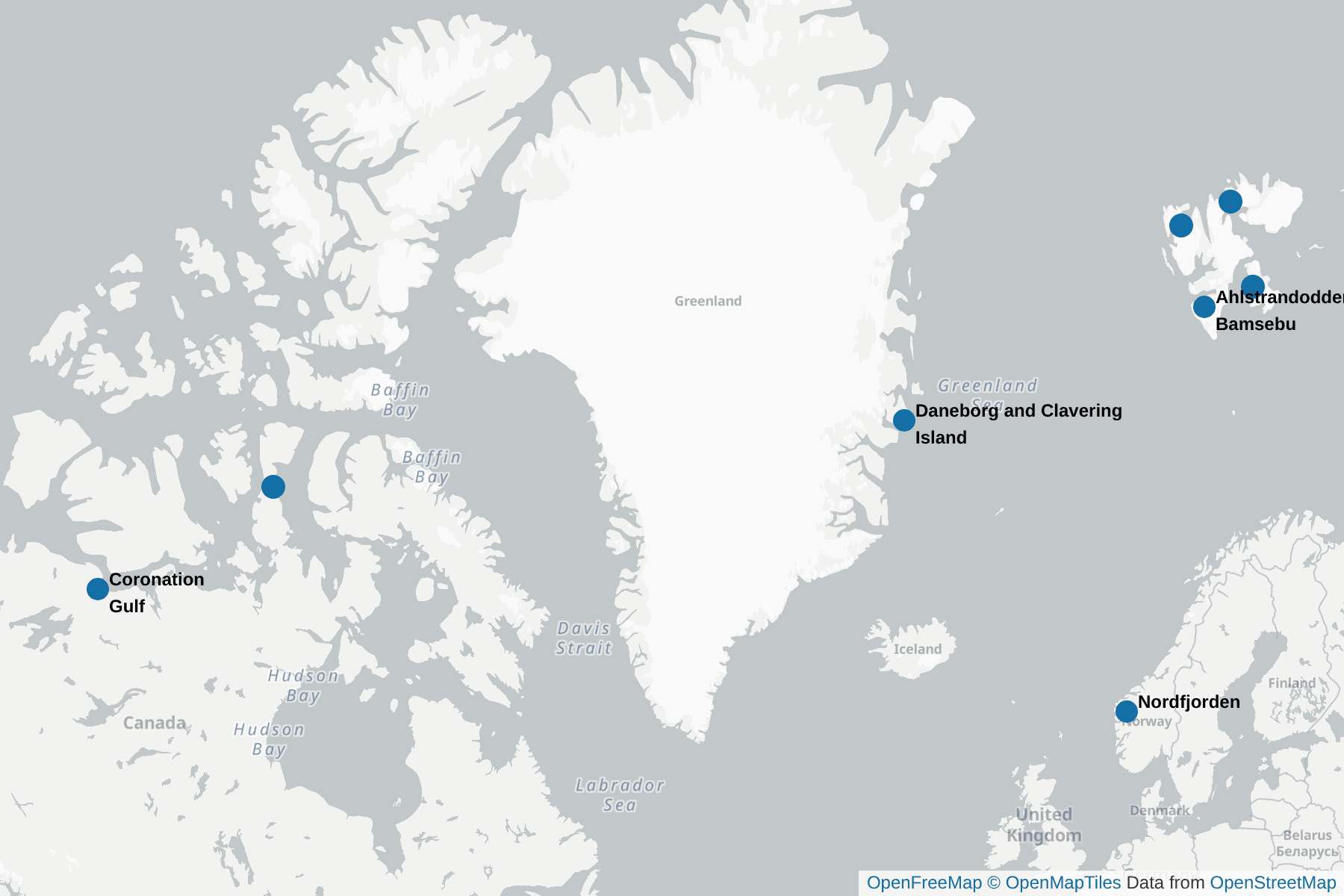
Highlights where the King Eider can be seen

QuarkExpeditions_Spitsbergen in Depth Arctic
Ahlstrandodden and Bamsebu

These two sites are at the entrance to the southern arm of Bellsund - Van Keulenfjorden. Both sites, and the area between them, are scattered with remains from the Beluga, the white whale, that was hunted for the blubber and skin. There are piles of bleached bones and upturned wooden boats that were left when the area was abandoned in the 1930’s.

Beluga can be seen along the shore here. If you are lucky to encounter them it is poignant with their bleached bones on the shore.

It is popular site for a landing and to walk across the tundra between the two sites, looking for Arctic flowers, Reindeer, Arctic Foxes, and check out some hunter’s cabins and the remains of fox traps.

Also look out for Purple Sandpipers and Red Phalaropes feeding along the shoreline.

Narwhal
Bellot Strait

Narrow strait separating Somerset Island to the north from Murchison Promontory of Boothia Peninsula to the south, the northernmost part of mainland America.

The 2km (1.2 mi) wide and 25 km (16 mi) strait connects the Gulf of Boothia, Prince Regent Inlet, and Brentford Bay to the east with Peel Sound and Franklin Strait to the west. It became a strait on ‘one’ of the NW passage routes. On a map of the Canadian Arctic, unless you look in detail, it is easy to assume the Boothia Peninsula and Somerset Island is one peninsula. In many ways, with Bellot Strait locked in ice much of the year, it is like the peninsula. Since it is so narrow, it can be a place to look for Narwhal, and, along the shore, Polar Bear, or even wolf.

coronation gulf
Coronation Gulf

The gulf is between Victoria Island and mainland Nunavut with the chance to see a more diverse range of Canadian Arctic birds compared to the areas of NW Passage further north. To the northwest it connects with Dolphin and Union Strait, thence the Beaufort Sea and Arctic Ocean; to the northeast it connects with Dease Strait and thence Queen Maud Gulf.

The northwest point is Cape Krusenstern (not the Cape Krusenstern in Alaska). South of that is Richardson Bay and the mouths (from west to east) of the Rae River, Richardson River and the large Coppermine River, Napaaktoktok River, and the Asiak River. At the southeast end is the large Bathurst Inlet. At the northeast end is Cape Flinders on the Kent Peninsula. In the center of the gulf lies the Duke of York Archipelago.

Greenland
Daneborg and Clavering Island

Daneborg, on the south coast of Wollaston Foreland peninsula, is the location of the Danish Sirius Patrol that patrols NE Greenland and the vast national park.

Cruise ships check in here coming in from Svalbard then explore nearby fjords, making sure sea ice coming south in the East Greenland current does block off the entrances to the fjord systems. Some of this sea ice can include multi year ice that has drifted south from the Arctic Ocean, in complete contrast to the warming influence of the Gulf stream on the west coast of Svalbard, not that far to the east.

Across Young Fjord is Clavering Island, were Clavering and his crew of the Griper encountered a band of twelve Inuit in August 1823. Later explorers to the region found no evidence of inhabitants in NE Greenland. There are the remains of Inuit settlements and it appears, when the the first European explorers turned up, the small population was already dying out or moving on. Possibly the combination of cold conditions at the time, and trying to survive in one of the harshest areas on the plane, even for the Innuit - NE Greenland. There was also a weather station on the island.

The 14th July Glacier
Fjortende Julibukta

The 14th of July bay and glacier, named by Prince Albert I of Monaco on the Princesse Alice on his oceanographic expeditions to Svalbard from 1898 to 1907.

It is one of the highlights in Krossfjorden, often combining a landing with a Zodiac cruise. Cruising along the impressive glacier front, there are regular calvings with bergs in the bay that attracts birds like kittiwakes. And nearby there are bird cliffs with a colony of Thick-billed Murres (Brünnich’s Guillemot) that also includes Atlantic Puffins. Options for landing (being careful of potential Tsunami waves from calvings) include one of the best spots in the whole of Svalbard for flowers, and even the chance to walk on the side of the glacier.

Ross Fort
Fort Ross

Fort Ross is an abandoned former trading post on Somerset Island. First established in 1937 by the Hudson's Bay Company, it was only operational to 1948, as severe ice conditions in the surrounding waters made the site hard to reach and economically unviable.

It is interesting to visit a Hudson’s Bay Company hut and to contemplate the location. It is situated at the eastern end of Bellot Strait on a south-eastern peninsula of Somerset Island, a key location in the northwest Passage. Also good for a rage of high arctic species.

Black-legged Kittiwake (Atlantic) (Rissa t. tridactyla)
Haleysundet

This is the sound between Spitsbergen and Barentsøya and a second way to reach Hinlopenstretet instead of Freemansundet.

However, with the extremely strong currents few captains go this way, and usually later in the season, when there is less chance of ice floes hurtling through on the current, and at the right stage of the tide. It is a spectacular ship cruise, often with lots of feeding seabirds. There is a nearby passage that is far too narrow to sail through, but there is the option to go through this narrow passage by Zodiac whilst the ship goes through the main channel and picks up the Zodiacs on the other side. A really exciting and fun Zodiac cruise!

Hinlopenstretet
Hinlopenstretet

The sound between Spitsbergen and Nordaustlandet in the high Arctic, in contrast to the milder coast of western Spitsbergen. Early in the season it is locked in ice that slowly clears from the south.

The northern end can be blocked by the pack for a while, varying from season to season. Once open, it enables circumnavigation of Spitsbergen, although ice can still drift in on strong currents and block Hinlopenstretet. When Hinlopenstretet is open, but the northern end is still blocked, ships will come into the area, typically sailing along Freemansundet between Edgeøya and Barentsøya, then return.

The area is superb for Zodiac cruises and landings, and can be superb even as a ship cruise. There are plenty of seabirds, the sound can be good for whales, there are various fjords to explore, like the surprisingly arid and desert-like Wahlenbergfjorden, various island groups to explore, like Wahlbergøya, and the chance to experience what is described as the polar desert. Three locations stand out as highlights in whole of Svalbard, the ice cliff Bråsvellbreen, the Walrus Haul out at Torellneset , and the bird cliff at Alkefjellet.

Kongsbreen og Tre Kroner
Kongsvegen and Kongsbreen

The inner part of Kongsfjorden is popular for ship cruising and especially Zodiac cruising with the mountain scenery, some impressive glacier fronts, and the chance to explore the ice floes looking for wildlife, and the chance of a bear.

Also keep a look out for Long tailed Jaegers, one of the few places they breed in Svlbard is on the island of Ny London in the middle of Kongsford. A number of lakes and pools in the region can attract a range of waterbirds.

Krossfjorden Spitsbergen
Krossfjorden

The two split fjords that form the inner part of Krossfjorden are popular for ship cruising and Zodiac cruising to enjoy the scenery, the glacier fronts, and to look out for wildlife and the chance of a bear.

There are also several options for landings including Möllerhamna, with a hunter’s cabin painted orange that is known the ‘Lloyds Hotel’. Many cruise ships have visited the site for over 100 years, leaving behind mementoes like signs, graffiti (no longer allowed), and a bar. Sigenhamna is another location where there was a German weather station in World War II.

Spitsbergen
Lågøya

This island, and the associated smaller islands, is off the NW coast of Nordaustlandet. Lågøya means ‘low island’, and it is the site of a Walrus haul out and is great for bird life, with the chance of Sabine’s Gulls that are attracted to the lagoons on the island.

Part of the island is sea¬so¬nal¬ly pro¬tec-ted and off limits and landings are often thwarted by the presence of a bear, or bears. It is an area where there can be loose pack ice when the pack, further to the east, is still too compact to sail though. It means this location very popular for Zodiac cruising with the wildlife that can be encountered. There is at least one old hunter’s cabin on the island, but conditions were particularly harsh on Lågøya, some perishing on the island, making hunters reticent of over wintering here.

QuarkExpeditions_ Northwest Passage Arctic Canada
Nordfjorden

There are several deep fjords along the north coast of Isfjorden with glaciers coming down to the bay. These can be popular for Zodiac cruises along the glacial fronts, discover wildlife, and in some places, even to get ashore to walk on a glacier.

Puffin Raudfjorden
Raudfjorden

Further around the Northwest coast of Spitsbergen, further to the east, this fjord is often blocked off by the pack ice in the early season before, but is the first area to become free as the pack ice retreats from the NW corner of Spitsbergen.

The mountains in this area are rugged and the coast here may have been the land that Barents saw when he came up with the name of Spitsbergen. The name, ‘red fjord’ comes from the red sandstone in the south and east areas of the fjord. There is a hunter’s wooden cabin at Bruceneset and a cairn for a pioneer that died of scurvy whilst overwintering in 1907/08. The name is for the explorer William S. Bruce, the area named by Prince Albert I of Monaco on the Princesse Alice on his oceanographic expeditions to Svalbard from 1898 to 1907.

Smeerenburgfjorden - Svalbard
Smeerenburgfjorden

This extensive fjord system has impressive scenery and numerous glaciers that is great to explore by ship whilst being on the watch out for bears. It is also an area with lots of history.

Smeerenburg was the base for the Dutch whalers that was known as ‘blubber town’, with the remains of the blubber ovens for those that get ashore. There is also a Walrus haul out that can be observed from the shore, or from a Zodiac if there is a bear nearby (quite often the case here in the NW). Close by is Virgohamna, the site where Andrée set off his ill-fated trip to the North Pole by balloon in 1897, and where Wellman attempted to fly to the pole in the early 1900’s. Today there are the scattered remains of the balloon shed and the aircraft hangar. Special permission is required to land but the remains can be seen from a Zodiac offshore. Smeerenberg was also the location where the Fram appeared after drifting across the Arctic Ocean, stuck in the ice for three years!

Arctic Beauty - Svalbard - Woodfjorden
Woodfjorden

This large fjord, and the associated Bockfjorden and Liefdefjorden in northern Spitsbergen, becomes accessible as the pack retreats. It is great for ship cruising, enjoying the scenery, and to look out for bears along the extensive coastline.

Flexibility is key with the chance of bears and changing weather conditions, but with plenty of choices in this large fjord complex. Zodiac cruises are popular, including Monacobreen glacier at the end of Liefdelfjorden, and the islands of Andøyane, a great area for a range of birds, including King Eider. There are also options for landings. The large and impressive wooden hut at Mushamna on the NE side of Woodfjorden. The small hunter’s cabin known as the Texas Bar in Liefdefjorden. The ‘thermal spring’ at Jotunkjeldane in Bockfjorden.

Our trips to spot the King Eider